Quantcast
Channel: The RAS Solution
Viewing all 200 articles
Browse latest View live

New Book - “Breaking the HEC-RAS Code” now available!

$
0
0

FrontCover 

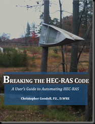
One of the most powerful, yet relatively unknown features available in HEC-RAS is the HECRASController.

The HECRASController API has a wealth of procedures which allow a programmer to manipulate HEC-RAS externally by setting input data, retrieving input or output data, and performing common functions such as opening and closing HEC-RAS, changing plans, running HEC-RAS, and plotting output. HECRASController applications are seemingly endless.  Not only can the retrieval and post-processing of output be automated, but with the HECRASController, real-time modeling and probabilistic experiments are possible. If you have HEC-RAS on your computer, you already have the HECRASController!

Breaking the HEC-RAS Code” explains how the HECRASController works, provides example applications of the HECRASController, and catalogs the vast array of programming procedures (with explanations and examples on how to use them) embedded in the HECRASController.

This is a "must-have" book for all HEC-RAS users. 

Professionals: Give yourself an edge for the next proposal and do something groundbreaking with HEC-RAS. 

Students: Make yourself marketable by adding the skills offered in this book.

You can purchase your copy now at my e-store by clicking the following link:  https://www.createspace.com/4701459.  It will also be available on Amazon and other on-line book retailers in the coming days. 

I think you’ll find the information in this book extremely useful in your efforts to control HEC-RAS from external applications.  Remember, all you need is this book, HEC-RAS, and Excel to do this.  You should also be able to access the HECRASController from most other programming platforms, if you prefer.  I’ve used it quite a bit in Visual Studio.    

I’d love to fill up The RAS Solution with positive quotes about the book from satisfied readers, so if you feel inclined, please let me know what you think.  And do me a favor, feel free to forward this email and/or the link to my book to all of your HEC-RAS friends.  Facebook share it, retweet it, +1 it, etc.

Stay tuned to The RAS Solution, for more information.  I want to eventually add a forum for users to discuss the HECRASController, and to upload and share code snippets that you create.   I will also be making available for purchase an Excel Workbook that has code examples for every HECRASController procedure, the example applications in the book, as well as some other useful code snippets. 

Here’s what some prominent HEC-RAS User’s are saying about “Breaking the HEC-RAS Code”:

“This book is the only complete resource that explains how to use the HECRASController in its entirety; and is comprehensive, easy to read, and well-documented. Chris has been writing code around HEC-RAS to solve unique problems for years. He has also suggested several ideas for expanding and improving the HECRASController. Chris has done an outstanding job with this book. Anyone with experience in HEC-RAS and a basic understanding of programming language will be able to use this book to help build applications that control HEC-RAS.   As the author and leader of the HEC-RAS development team, I highly recommend this book to anyone who wants to take HEC-RAS and expand its capabilities in order to solve challenging hydraulic engineering problems.”  -Gary W. Brunner, P.E., D.WRE, Leader of the HEC-RAS Development Team

Breaking the HEC-RAS Code presents detailed, well-organized instructions for one of the most underutilized yet powerful aspects of HEC-RAS.  Readers will continually say "I didn't know you could make HEC-RAS do that!" This book is a must for anybody who frequently uses HEC-RAS.  The examples are thorough and complete.  The instructions on coding are easy to understand even for beginner coders.”Brian Wahlin, Ph.D., P.E., D.WRE

“Chris Goodell’s new book Breaking the HEC-RAS Code is essential for any frequent HEC-RAS user. It provides great insights into how to most easily customize and optimize use of the code, as well as some of the program’s lesser known capabilities.  This book simplifies HEC-RAS and also magnifies the efficiencies of hydraulic modeling. I would expect something of this quality from Chris, who worked on the HEC-RAS Development Team and is an internationally-recognized expert in the intricacies of HEC-RAS.”  -Jeffrey B. Bradley, Ph.D., P.E., D.WRE, F.ASCE, Past-President EWRI and AAWRE of ASCE

“I have been working with the HEC-RAS software package for over 14 years. When Chris gave me the opportunity to review his new book, I was very excited. Through his hard work, he has opened the window to utilize HEC-RAS in countless new ways and provides engineers a way to bring more value to projects and clients. I would not consider myself a programmer, but thanks to this book, I have a very good starting point and road map to use HEC-RAS in new and exciting ways.” –Matt Zeve, P.E., CFM, ASCE HEC-RAS Instructor and Houston Area Manager, IEA Inc.

“Chris Goodell’s Breaking the HEC-RAS Code is a comprehensive guide to HECRASController, a set of programming procedures that give the user control over the operation and behavior of the well-known Hydrologic Engineering Center’s River Analysis System (HEC-RAS) hydraulic modeling software. By using this book, an HEC-RAS modeler can learn to customize and automate the complete process, including opening the software, modifying data input, running the simulation, and retrieving output from the HEC-RAS binary output file. If you’ve written programs for the old HEC-2 software, predecessor to HEC-RAS, but were thwarted by the binary output secrets of HEC-RAS, you’ll be thrilled to learn the tricks using Chris’s thorough descriptions and examples based on Visual Basic for Applications (VBA). If you’ve never written programs for modifying modeling software but are eager to jump in, this is a good place to begin. Chris has done an excellent job in writing this book that is comprehensive and well thought out. While maybe not for the casual HEC-RAS user, this book will be a tremendous resource for anyone who wishes to automate and control HEC-RAS to solve complex hydraulic engineering problems.”  -Gary Wolff, P.E., D.WRE, Senior Hydraulic Engineer and HEC-RAS Instructor, OTAK Inc.

“Using HEC-RAS for Dam Break Studies”

$
0
0

Written by Christopher Goodell, P.E., D.WRE  |  WEST Consultants

Copyright © The RAS Solution 2014.  All rights reserved.
 

HEC recently published a new training document called “Using HEC-RAS for Dam Break Studies”.  Written by Gary Brunner, P.E., D.WRE, it is an easy to follow guide for performing Dam Break simulations in HEC-RAS.

  image

It covers topics like:

  • Which routing technique to use to route flows through your reservoir (Dynamic or Level Pool-although I wish they had included my method and Kopsky’s method),
  • Estimating dam breach characteristics, including some of the newer erosion process models,
  • Downstream flood routing/Modeling issues.  For those of you who have or have had troubles with stability while trying to route a dam breach hydrograph, this last section will be very helpful. 

The document also covers dam break modeling using the new 2D features in HEC-RAS and provides some nice example applications.  This document should be on your desk, ready to reference, for every HEC-RAS dam break study you work on.   

You can download “Using HEC-RAS for Dam Break Studies” from the HEC website at http://www.hec.usace.army.mil/publications/TrainingDocuments/TD-39.pdf

   -or-

from my Google Drive site at:  https://drive.google.com/file/d/0B0bpiyLiUeRXSHpCR2s4RjdCeFk/view?usp=sharing

Retrieving Output Automatically

$
0
0

Written by Christopher Goodell, P.E., D.WRE  |  WEST Consultants

Copyright © The RAS Solution 2014.  All rights reserved.

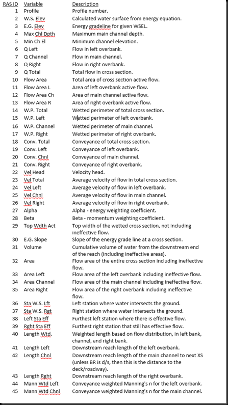
Did you know that there are 268 output variables that you can retrieve automatically using the HECRASController?  That’s right, everything from velocity in the main channel, to shear stress, to stream power, to hydraulic depth, and of course water surface elevation.  There’s more than you can possibly ever want or need.  The post “Automating HEC-RAS” demonstrates how to get started with this.  To access any of the 268 variables, you can use the HECRASController Output_NodeOuput subroutine or the Output_ReachOutput function.  Both of these are described in detail in “Breaking the HEC-RAS Code”.

Here’s just a sample of the variables and their respective IDs.  The rest are included in “Breaking the HEC-RAS Code”, and can also be found in the profile output table in HEC-RAS.

image

New Positions available at WEST Consultants

$
0
0
Hey Everyone-
We’re looking to add to my staff here in the Portland, OR office of WEST Consultants.  We are looking for talented, forward-thinking, problem-solving, ambitious, and creative hydraulic engineers to work with me and my staff on some exciting projects.  WEST offers a dynamic work environment where our talented teams are solving some of the most challenging projects in water resources engineering.  We have two positions in Portland, Oregon that we’re considering excellent candidates for:
  • Entry Level.  Masters Degree in Water Resources Engineering (or related) with 0-5 years experience.
  • Senior Engineer/Project Manager.  Masters or PhD in Water Resource Engineering (or related) with 7-15 years experience and a PE. 
The more experienced position will be expected to market and bring in work.  Both positions will be expected to perform highly technical work with 1D and 2D hydraulic modeling, hydrologic studies, sediment transport modeling, and code development.  In addition to being technically superior, you’ll be expected to be able to communicate at a high level with clients and colleagues both verbally and in written form.  Ability to confidently write and present papers is also expected.  I’m looking for the best of the best.  If you’re interested in joining our team, please tell me why you are the “best of the best.”
Please don’t just send resumes.  Research WEST Consultants.  Know what we do.  Then tell me how you will fit in here and why we should hire you. 
For more information, and to submit your cover letter and resume/CV please visit this link:
http://www.westconsultants.com/careers

11th National Hydrologic Warning Council Training Conference and Exposition-Call for Abstracts

$
0
0
The Call for Presentation Abstracts for the 11th National Hydrologic Warning Council Training Conference and Exposition is now available. Scheduled for June 16-18, 2015 in Indianapolis, IN, the event will highlight “Advances in Hydrologic Warning – The Race to Save Lives.” The conference provides a multidisciplinary hydrologic warning training experience for field personnel, engineers, hydrologists, forecasters, water resource managers, emergency management officials, and others. The program includes a wide range of technical sessions covering the needs of those just getting started to those with advanced needs.

Including Channel Bathymetry into your Terrain.

$
0
0
Written by Christopher Goodell, P.E., D.WRE  |  WEST Consultants
Copyright © The RAS Solution 2014.  All rights reserved.

Let’s say you have a digital terrain model of the area you want to model with 2D HEC-RAS.  ONLY 2D RAS.  In other words, you want to lay out a grid, but do not want to have do to any 1D computations-all 2D.  The problem is the area you want to model includes one or more rivers and streams that have no bathymetric (under water topography) data represented in the digital terrain model.  This is a common problem as many sources of terrain data are collected today using LiDAR (Light Detection And Ranging).  As great as LiDAR is for collecting surface data, conventional forms of LiDAR do not penetrate water. 

To adequately model 2D in RAS,
you need a terrain of your entire modeled area-including the stream channels.  HEC has come up with an easy way to weave in a channel terrain with your LiDAR terrain, IF you already have cross sections of the channel.

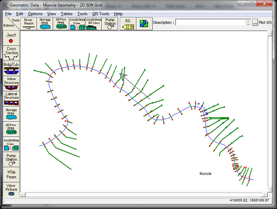
Open an HEC-RAS project in Version 5.0 (beta or newer) that has your cross sections represented in a geometry file.  The figure below shows an existing model of the White River in Muncie, Indiana USA.  This is from one of the standard 2D HEC-RAS data sets that come with HEC-RAS 5.0 beta.
image
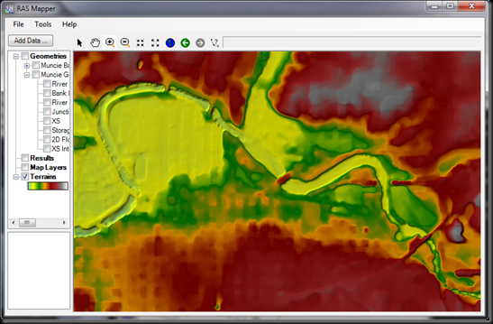
We wish to lay a grid over this entire area to model it as 2D only.  A major problem here is that the terrain below the water surface of the White River is not included in the Terrain that we have obtained.  Notice that there is no relief represented within the stream, and in fact the bridges that cross over the White River are included in the original terrain.  Bridges should not be included in the terrain-they can be added as model components in the geometry window, if it is desired to include them in your model. 
image
HEC has provided a way to easily incorporate our cross section data into the terrain for a single comprehensive terrain model that includes bathymetry (and no bridges in the terrain!):
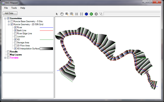
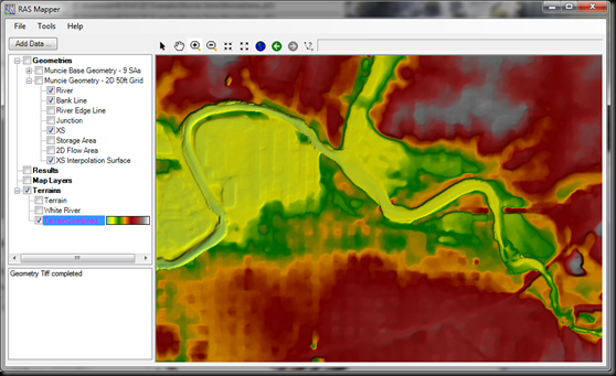
1.  In RAS Mapper, first make sure a geographic projection is selected (Tools…Set Projection for Project…).  Then select to view the geometry that has the cross sections you want to include in the terrain.  Then check the features River, Bank Line, XS (XS stands for cross section), and XS Interpolation Surface.  It should look like this:
image
Here you can see, that just by having cross sections in a geometry file, RAS has already created a conceptual interpolated surface from those cross sections.  Each pair of cross sections is linearly interpolated.  This is very similar to the cross section interpolation routines in the tools menu item of the geometry window.  Only here, instead of adding interpolated cross sections, we’re developing a continuous surface that can be made into a terrain.  RAS does all of this for you, all you have to do is enter cross sections into your geometry, and check the box that says XS Interpolation Surface. 
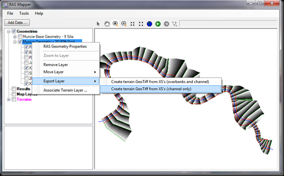
2.    From the data file tree on the left,  right-click on the name of the geometry file you’re working in and select Export Layer…Create terrain GeoTiff from XS’s (channel only).  We select channel only, under the presumption that the LiDAR data has better resolution than the cross section data, so where the two sources overlap (i.e. in the overbanks), we’ll stick with the LiDAR data.   If channel only is selected, RAS will create the new terrain between the established Bank Lines (polylines that spatially connect the cross section bank stations). 
image
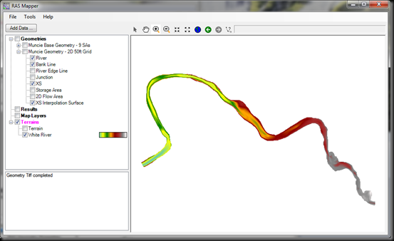
Once you select to create the terrain from XS’s, RAS will ask you to name the new terrain (a GeoTiff) and where to store it.  It will also ask you to enter in a raster cell size.  This is the grid cell size that RAS will set this new terrain to.  It should be representative of the resolution of the station-elevation data that make up your cross section.  You can view the new terrain by selecting Tool…New Terrain. 
image
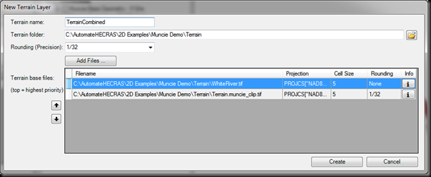
3.  Once you’ve added the new channel, a new terrain can be created that combines both the original LiDAR-based terrain with the new channel terrain.  Select  Tools…New Terrain.  This time you’ll add both two files: the original terrain and the new channel terrain.
image
Make sure that the channel terrain (in this example…White River.tif) has the highest priority by moving it to the top of the list using the arrow button on the left.  This will ensure that where ever the two terrains overlap, the channel terrain will be used in creating the new single comprehensive terrain. After clicking the Create button, a new terrain is created that combines both the channel bathymetric data (interpolated by cross sections) and the original LiDAR-based terrain. 
image
Now you’re ready to lay down a mesh and run your 2D model.   More information on working with terrains in HEC-RAS 5.0 can be found in the document “Combined 1D and 2D Modeling with HEC-RAS”.  Check the link on the side bar to download the latest version of HEC-RAS. 

New HECRASController Forum

$
0
0
Happy New Year RAS Modelers-

I've added a new sub-forum for HECRASController users to post questions and comments specific to the HECRASController and to submit sample code that you would like to share with others.  As you do more and more programming with the HECRASController, please consider sharing some of your useful code with others.  I plan to periodically post code both from the book "Breaking the HEC-RAS Code", and from real projects I've worked on.  A good primer for controlling HEC-RAS using the HECRASController is located here.

The new forum can be found in the forum tab on the top of this page, or by following this link.  "Breaking the HEC-RAS Code" is available from my e-store and from Amazon and other on-line book retailers.

Have fun!

Updated Errata Sheet for Breaking the HEC-RAS Code.

$
0
0
For all of you who have a copy or are planning to get a copy of "Breaking the HEC-RAS Code", there's an updated Errata Sheet on the bottom of the "Book" page of this blog.  Although I spent a LOT of time hunting down and correcting errors before publishing, it's inevitable that some of these will show up.  As always, please let me know if you find any more.

And also, many of you have already emailed me with examples of code you've written by using the techniques presented in the book.  I love it!  Thanks.  Keep up the good work and if you've written something you think will be useful to others, or you just want to show off :-), please post it in the forum under the HECRASController sub-forum.

HEC-RAS Model with 2D Mesh Only.

$
0
0
Written by Christopher Goodell, P.E., D.WRE  |  WEST Consultants
Copyright © The RAS Solution 2015.  All rights reserved.

There have been many questions lately about whether HEC-RAS 5.0 can perform a simulation with ONLY a 2D mesh (i.e. no cross sections).  The answer is yes.  In fact, in many ways it’s a lot easier.  In this example, the standard Muncie project offered by the Hydrologic Engineering Center has been converted first to SI units, then to a single 2D mesh.  To keep things simple, the levee breach was removed and flow moving into the overbank areas is purely due to overtopping of the levee.  The following figure presents the geometry file for Muncie when modeled with a single 2D area.   

image


Once you’ve drawn your 2D area boundary and have assigned a mesh cell center spacing (DX and DY) and Manning’s roughness value(s), really all that is left is to
assign boundary conditions at the upstream and downstream ends using 2D Area BC Lines.  These were placed at the same location as the upstream and downstream cross sections from the original model. 
The easiest way to set initial conditions is to just apply a single starting water surface elevation for the entire domain.  This will not always work, especially if there is significant changes in water surface elevation throughout the 2D area.  But in this case it worked, with a little help from the Initial Conditions Ramp-Up option in the Unsteady Computation Options and Tolerances window.  I used a ramp-up time of 4 hours to set the model up with a more appropriate initial conditions solution.

image

In the 2D mesh, you’ll also notice I’ve added some refinement to the initial 40m x 40m cell center spacing to better capture the geometry along the levee and to minimize inundation fragmentation. 
Notice in this figure I’ve oriented some additional cell centers to try to align the cell faces with the high ground just to the southwest of the main channel.  This helps to prevent “leaking” through the high ground, which occurs when a cell is large enough to straddle the high ground feature. 

image

As shown in this figure, I added some resolution and strategic cell center orientation to minimize inundation fragmentation.  A lot more of this could be done with this data set to completely eliminate fragmentation. 

image

Over 2 days of simulation time with a 10 second computation interval and 40 m x 40 m initial cell size ran rather quickly at around 2.5 minutes on my computer. 

image

This sample data set is available from The RAS Solution Google Drive site at:
https://drive.google.com/file/d/0B0bpiyLiUeRXMHhZVU9ibm5faUk/view?usp=sharing

I didn't include the output files, so make sure to run the simulation first.

Please note that this data set is completely fictional and represents no real flood event-past, present, or future.  This data set was originally developed by the Hydrologic Engineering Center and modified by me.  It is meant strictly for demonstration purposes.  Enjoy!

HEC-RAS 2D - Upcoming Training Courses!

$
0
0
Don't miss out on these opportunities to be among the first to get training on HEC-RAS 2D!


2D Free Surface Flow Modeling
SANCOLD 2015 Conference in Pretoria, South Africa.  February 2-6, 2015

logotype
http://www.sancold.org.za/images/2D_Free_Surface_Flow_Modeling_Course.pdf


Two-Dimensional Modeling using HEC-RAS
ASCE Live Seminar, Tampa, Florida USA, February 25-27, 2015

http://mylearning.asce.org/diweb/catalog/item/id/242087/q/c=79&q=hec-ras&t=2122&t=2115


2D HEC-RAS Workshop
Floodplain Management Association, McClellan, California, March 10-12, 2015.
http://membersfloodplain.site-ym.com/events/event_details.asp?id=569705

HECRASController VBA Code-Companion to “Breaking the HEC-RAS Code”

$
0
0
Written by Christopher Goodell, P.E., D.WRE  |  WEST Consultants
Copyright © The RAS Solution 2014.  All rights reserved.

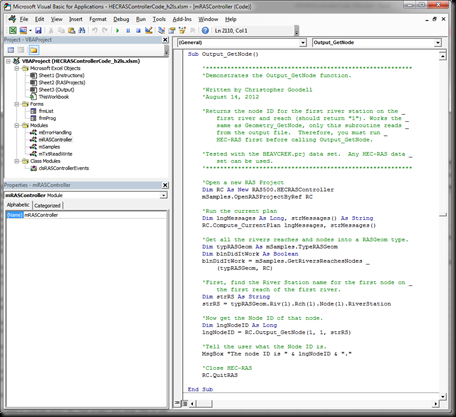
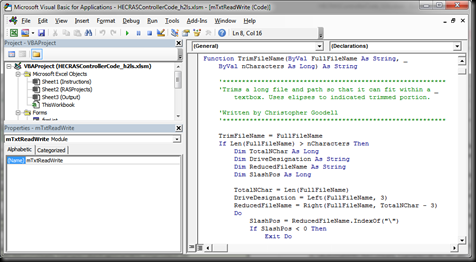
There has been a lot of demand from new owners of the book “Breaking the HEC-RAS Code” for example code in VBA form.  So…here it is!  Aside from the obvious fact that you wont have to re-type code from the book into your own Excel VBA modules, this Excel Workbook provides the benefit of seeing how each and every procedure in the HECRASController works.

 image
That’s right, every subroutine, and every function are documented in this workbook, along with example code from a wide range of HEC-RAS automation procedures and some code snippets for error catching and string manipulation-very important when reading/writing HEC-RAS input files.  In total, there are over 150 procedures and over 8000 lines of code for you to use for help while you create your own HEC-RAS automation projects.


Each procedure from the HECRASController is demonstrated in either a subroutine or function in this Excel Workbook.  Each demonstration provides up-front commentary including the procedure's name, what it does, cautions and pitfalls to look out for, as well as what standard HEC data set it was tested with (i.e. Bald Eagle Creek, Beaver Creek, etc.). 


image
There’s also commentary all throughout each demonstration so that you’ll know exactly what each block of code does.  

The HECRASController VBA Code Excel Workbook will make a valuable companion to “Breaking the HEC-RAS Code”.  Every bit of code presented in the book is available in digital form in the Excel Workbook.  The HECRASController VBA Code is optimized for Version 5.0 of HEC-RAS. It will work right now with the current beta release, and will work with the official version when it is released.  

The HECRASController VBA Code Excel Workbook is available here:


2D Troubleshooting – Fragmented Inundation

$
0
0
Written by Christopher Goodell, P.E., D.WRE  |  WEST Consultants
Copyright © The RAS Solution 2015.  All rights reserved.

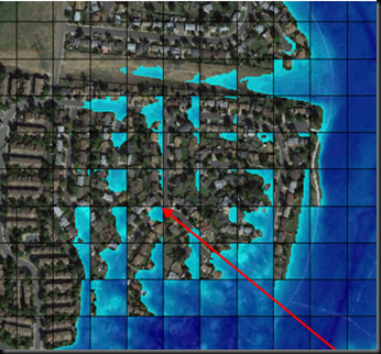
(Initial post 19 Feb., 2015.  Updated 20 Feb., 2015).  I continue to be more and more impressed with how user-friendly and robust the new 2D feature is in HEC-RAS.  However, there are some issues to be aware of, particularly in how results are mapped.  I want to take the next two blog posts to highlight two of the more important mapping problems to be aware of.  Today’s post covers what I call “Fragmented Inundation”, or fragmented mapping.  If you’ve run some 2D data sets already, you are likely to have seen this, especially if your 2D area starts off dry, you have steep terrain, and/or your cell size is too large.  Fragmentation usually shows up just as a part of a 2D area becomes wet (i.e. very shallow depths), and tends to go away as depths increase.  Very rarely do you see fragmentation in the maximum water surface plot.  Here’s an example of fragmented inundation:
image
Notice the isolated “ponds” of water in some cells, disconnected from the water in its neighboring cells.

First off, fragmented inundation is mostly a graphical phenomenon.  By that, I mean computationally a hydraulic gradient is realized between neighboring cell centers.  Fragmentation appears simply because currently the computations in HEC-RAS result in a single water surface elevation per cell.  During computations, a hydraulic gradient over the cell is computed in 2 dimensions using the fully dynamic or diffusive wave form of the conservation of momentum equation (your choice) coupled with the conservation of mass equation.  One thing to keep in mind is that currently the cell face hydraulic parameters between the two cell centers is based on the higher of the two neighboring water surface elevations.  An average between the two cell center elevations would make more sense hydraulically, but computationally this can cause problems, particularly if there is an inflection (i.e. high ground) over the length between the centers, in which case it could result in a water surface elevation lower than then lowest ground point in the cell face.  This produces a small amount of error, particularly in steeper terrain, but is not the reason for fragmented inundation, as it is plotted in RAS Mapper.
image
When plotting results in RAS Mapper, HEC-RAS will use a single water surface elevation computed per cell and plot that.  Normally, with sufficient water depths, this would go unnoticed.  However, when water first enters a portion of a 2D area, depths are very low, and fragmentation may show up initially, especially if the terrain is steep and the cell size is relatively large.
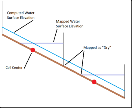
Take the following example of a 2D mesh in profile view, where cells are too large on a steep slope.  
image 
Here we have two neighboring cells, with water flowing from left to right over steep terrain.  The computed water surface elevation is a graphical representation of how the conservation of momentum and continuity equations are solved.  In reality, the cell face hydraulics will be based on the water surface elevation from the upper cell center and the depth difference between the mapped water surface elevation and the computed water surface elevation at a cell face can be considered a schematization error.  However, computationally, a water surface gradient is realized between the cell centers, but when plotted, a single average water surface elevation is used for the entirety of each cell.  If the depth is too low, you’ll have dry portions in between wet portions, resulting in fragmented inundation. 
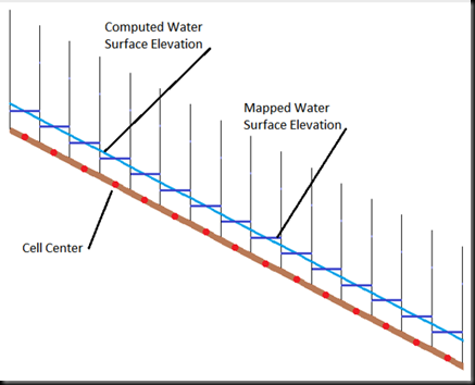
Now take the same terrain, but with smaller cells:
image
With the smaller cell size, each entire cell will be completely wetted for the same computed hydraulic gradient, resulting in a smoother, more realistic-looking inundation map.
Decreasing cell size will help to reduce or eliminate fragmented inundation and the schematization error associated with how cell face hydraulics are computed, but so will strategic alignment of the cells in the direction of flow.  However, before going to the trouble to reduce cell size everywhere this happens in your 2D area, ask yourself if it’s really important to fix this.  Remember, computationally a hydraulic gradient is still realized over the length between cell centers, even when you see fragmented inundation.  The visualized fragmentation is an artifact of how the HEC-RAS computational scheme arrives at a single water surface elevation for a given cell, and plots that water surface elevation.  If you are most interested in the maximum inundation, then eliminating fragmentation at the beginning of the flood event may not be necessary.  I have been told that future versions of HEC-RAS will be able to plot sloping water surfaces over individual cells, but for now we’ll have to understand fragmented inundation and what it means in our results. 
When checking your inundation maps, if you see fragmented inundation, make sure that is indeed what is going on by checking the underlying terrain.  Another, more serious mapping error called “leaking” can look similar to fragmented inundation.  Leaking is a result of high ground terrain not being captured in the cell faces, thus allowing water to seemingly flow through barriers.  This must be addressed in your model for an accurate solution.  I will discuss leaking in the next post (coming soon!).
In the meantime, keep checking back here for the official release of HEC-RAS Version 5.0.  Latest word is that it will be offered to the public by the end of this month (February 2015) or early next month.

(Thanks to Vern Bonner for providing expert critique to the initial post!)

Sediment Transport Features in HEC-RAS 5.0

$
0
0
Written by Stanford Gibson, Ph.D. |  Hydrologic Engineering Center
Copyright © Stanford Gibson 2015.  All rights reserved.

The new 2D features and mapping tools are the most anticipated new features in HEC-RAS 5.0. However, HEC also added a couple major new sediment features, as well as many minor features and a few substantial bug fixes (e.g. SI Units). The two major features are the ARS-USDA Bank Stability and Toe Erosion Model (BSTEM) and Unsteady Sediment transport.

USDA-ARS Bank Stability and Toe Erosion Model (BSTEM)
HEC collaborated with Andrew Simon (Cardno) and Eddy Langendoen (USDA-ARS) to couple the HEC-RAS mobile bed model with the USDA-ARS Bank Stability and Toe Erosion model (BSTEM).  This model coupling adds BSTEM’s lateral processes (geotechnical bank failure, groundwater lag and toe scour) to HEC-RAS’ vertical, deposition and erosion processes.  This tool has a separate User/Technical Reference manual available from HEC.

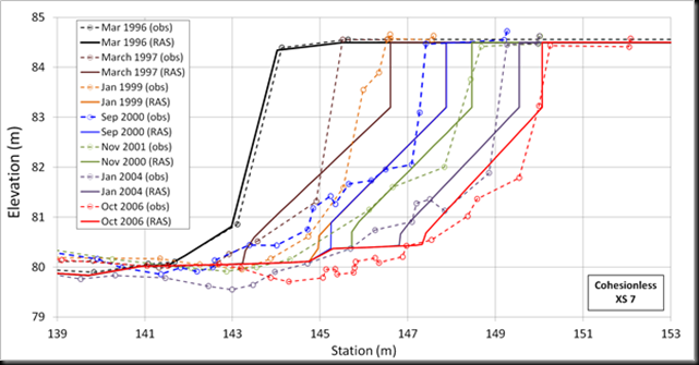
image
Goodwin Creek, MS, repeated right bank surveys compared with computed HEC-RAS/BSTEM cross section migration from Gibson et al. (2015).
 
Unsteady Sediment Transport:
Previous versions of sediment transport in HEC-RAS used the quasi-unsteady hydraulic model exclusively, simulating hydrodynamics with a series of steady flows. HEC-RAS 5.0 couples the sediment computations with unsteady flow. Hydrologic mass conservation is the biggest advantage of unsteady sediment transport, making reservoir models and even multi-reservoir cascade models much more practical in HEC-RAS. However, coupling sediment transport to the unsteady flow capabilities also brings several powerful features, native to the unsteady hydraulic analysis environment, into sediment transport analyses including: lateral structures, flow networks, mixed flow (figure), and especially operational rules (Gibson and Boyd, 2014). Version 5.0 even includes sediment based operational parameters, operating structures based on bed change and concentration (e.g. TMDL).

image
Initial and bed profile and water surface elevation for a mixed flow sediment transport simulation with equilibrium sediment load and hard bottom. Sediment deposited in the sub-critical reach.
 
Other Features:
HEC-RAS 5.0 also includes a range of other new sediment features including:
· HDF5 Sediment Output and a New Sediment Output Viewer
· Copeland (1993) Sorting and Armoring Method (Exner 7 in HEC 6T)
· Gradational Hotstart
· Sediment Flow Splits
· New Dredging Tools
· Bed Roughness Predictors
· New User Manual
· DSS Sediment Time Series Boundary Condition
· Specific Gage Capabilities

image


HEC-RAS 5.0 will be released shortly. To test a final beta version contact Stanford Gibson at HEC.


References:
Copeland, R (1993) Numerical Modeling of Hydraulic Sorting and Armoring in Alluvial Rivers, PhD Thesis, The University of Iowa, 284 p.

Gibson, S. and Boyd, P. (2014) “Modeling Long Term Alternatives for Sustainable Sediment Management Using Operational Sediment Transport Rules,” Reservoir Sedimentation –Scheiss et al. (eds), 229-236.

Gibson, S., Simon, A., Langendoen, E., Bankhead, N., Shelley, J. (2015) A Physically-Based Channel-Modeling Framework Integrating HEC-RAS Sediment Transport Capabilities and the USDA-ARS Bank-Stability and Toe-Erosion Model (BSTEM), SEDHYD Interagency Sediment Conference, April 2015, In Press.


Status on HEC-RAS 5.0

$
0
0
Written by Christopher Goodell, P.E., D.WRE  |  WEST Consultants
Copyright © The RAS Solution 2015.  All rights reserved.

Many of us were hoping to see the official release of HEC-RAS version 5.0 around now (end of Feb, early March, 2015), but unfortunately there have been some delays due to a large amount of bug fixes and HEC won't be releasing it as planned.  I haven't been provided with a new date, and I don't want to guess, but I don't think it will be too much longer.  Keep checking back here at The RAS Solution, or at HEC's website for the latest information on the official release.

The good news is this delay will give HEC some more time to include some more really cool and useful features.  Potential new features are shown below.


I don't have all the details on these features yet, but the 2D Area Breaklines tool looks to be a quick and convenient way to align cell faces in your 2D mesh around terrain features-this will save a LOT of time setting up and editing your mesh.  The 2D Area Mann n Region will allow you to draw polygons directly in the HEC-RAS Geometry editor for region-specific n-value factors.  It won't initially replace the need for a land-use shapefile, but will allow you to more easily run calibration on your n values.

In the meantime, the October Beta version of HEC-RAS 5.0 is still available and works very well. You can get the install file here or on the side bar of The RAS Solution.

2D Mesh “Leaking”

$
0
0
Written by Christopher Goodell, P.E., D.WRE  |  WEST Consultants
Copyright © The RAS Solution 2015.  All rights reserved.

To follow up mypost on fragmented inundation, I want to highlight another 2D mesh issue we should all be aware of.  Unlike fragmented inundation, which is an artifact of how HEC-RAS discretizes the 2D domain and the way it maps the results, Leaking is a result of terrain features not aligning with cell faces and/or cells that are too large, and can produce very wrong results. 
Take the following example of leaking.

image

Here we see a high ground feature that is straddled by rather large cell.  HEC-RAS will preserve the underlying terrain on the cell faces, but the cell itself is resolved to a volume-elevation curve.  Since the high ground feature runs diagonally through the cell, it is not picked up by the cell faces.  As a result, HEC-RAS does not know that there is a barrier that should keep water on one side of the high ground feature before it is overtopped.  The consequence is that water leaks through the high ground and is available to move further down the channel even before the high ground is overtopped.  This is incorrect.  To better capture the high ground feature, cell faces in this vicinity should be aligned to the high ground feature so that the terrain is picked up on the cell faces, which will prevent leakage.  The following figure shows the resulting flood map at the same time in the simulation as the figure above. 

image

Here we see the entire mesh has been overall refined to a smaller cell center spacing, but in addition, much more resolution was added by manually straddling cell centers around the high ground feature.  Notice around the crest of the high ground feature, the cell centers were placed to align the cell faces with the contours.  This ensures that the high ground is picked up by the cell faces.  The result is a higher resolution flood map, but also, and more importantly prevents leakage through the high ground before it is overtopped.  Also important is to provide much smaller cells on the downstream slope of the high ground feature, to prevent fragmented inundation.  In hindsight, I probably went a little overkill on adding cell centers, but it didn’t really add any noticeable time to the simulation, so I’m good with it. 
Manually adding cell centers is not particularly precise, and can take a bit of time.  Fortunately HEC will be including a new feature in the full release of 5.0 that allows the user to define a breakline along high ground terrain features like this.  The mesh is then generated, automatically aligning the cell faces to that breakline. 

Mac In Black Productions

$
0
0
You may notice some new background imagery on The RAS Solution.  Mac In Black Productions has been very kind to allow me to showcase some of his photos on the blog site.  He has some fantastic photos and does an amazing job blending nature and infrastructure.  I especially love his photographs of rivers, streams, and bridges.  Go follow his site and you'll see why: @macinblackproductions.

2D Mesh “Leaking” Part 2 – 2D Area Breaklines

$
0
0

Written by Christopher Goodell, P.E., D.WRE  |  WEST Consultants
Copyright © The RAS Solution 2015.  All rights reserved.

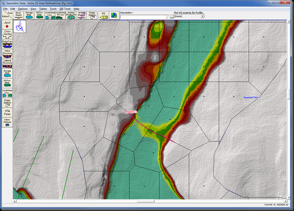
Continuing on with the discussion on leaking in 2D meshes, I want to highlight a new feature that will be included in the full release of Version 5.0 (hopefully due out early this summer).  The new feature, 2D Area Breaklines, will make aligning cell faces on to high ground features a snap!  Essentially, you draw breaklines along the crest of high ground features in your topography that will completely or temporarily act as a barrier to water flow.  A good example of this is a levee or berm.  As discussed in the previous post, we need to have our cell faces aligned to the high ground of these features so that the terrain is properly picked up in our mesh.  Here’s the same example found in the Muncie data set.  I’ve set the cell size to be rather larger through here, but certainly of an adequate size.  As shown, there is a high ground feature with a slightly lower overflow section that (when the stage is high enough) will allow flow to spill northward and continue up the floodplain. 

image

Notice that there is a cell that sits on top of the overflow section and straddles its high ground.  Running the model this way will allow flow to leak through the high ground feature, even before the high ground is overtopped, as shown below.  The example simulation below actually leaks water through the high ground a full 4 hours and 50 minutes before it is actually overtopped.  Not good!

image

In previous RAS 5.0 beta versions, to fix this you had to manually add cell points to align your cell faces.  In this example, that is not too hard, but you can imagine that with a long high ground feature and small cell sizes, this can take quite a bit of time. 

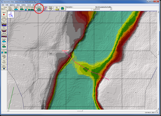
With the pending full release of Version 5.0, you can now let 2D Area Breaklines do the work for you. 

image

Select the 2D Area BreakLines button and click a series of points on your schematic to draw your breakline.  Double-click for the last point and at the prompt, give your breakline a name.


image 

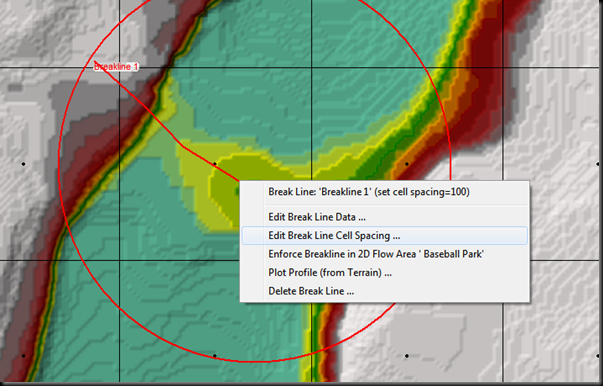
Left-clicking on the breakline will provide you some options for control over how your breakline re-adjusts cells.


image

Select Edit Break Line Cell Spacing to specify the spacing of cell points around the breakline.  In this example, I used a slightly higher center spacing so that the cells on the downstream side of the high ground feature extends all the way to the low spot (It is important to not have cells completely contained on a slope of a high ground feature like a levee or berm-I’ll save this topic for another discussion)

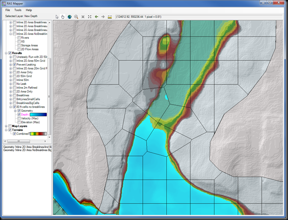
Now simply left-click again and select “Enforce Breakline in 2D Flow Area…” and RAS automatically redraws the mesh, respecting the breakline and the specified breakline cell center spacing. 

image

Now we can see that the high ground feature no longer leaks and only allows water to pass to the next cell once it is overtopped.


image

It’s important to note that there is some fragmentation downstream of the crest.  This is normal for water flowing over steep terrain.  You could go to the trouble of reducing the size of cells as I did in the previous post to eliminate this issue, but as with all modeling decisions in HEC-RAS, you must determine if that effort is worth it based on your overall study objectives. 

New HEC-RAS 2D Modeling User’s Manual

$
0
0
In advance of the final release of Version 5.0 (hoping for this summer), HEC has released its 2D Modeling User’s Manual, written by Gary Brunner, the HEC-RAS Team Leader.  This manual contains updates to all of the information that was put out in the previous guidance document, “Combined 1D and 2D Modeling using HEC-RAS” as well as more discussion on developing your terrain, creating the 2D mesh, combining with 1D elements, and avoiding errors and instabilities.

If you plan to run a 2D or combined 1D/2D model in HEC-RAS, please read this manual.  Mr. Brunner has done a fantastic job putting together this very well-written document with easy-to-understand instructions and guidance for setting up and running a 2D or combined 1D/2D model in HEC-RAS. 

You can get a free electronic copy of the HEC-RAS 2D Modeling User’s Manualhere, or by clicking on the link on the side bar to the right. 
 
An excerpt from the Introduction:
“HEC has added the ability to perform two-dimensional (2D) hydrodynamic flow routing within the unsteady flow analysis portion of HEC-RAS. Users can now perform one-dimensional (1D) unsteady-flow modeling, two-dimensional (2D) unsteady-flow modeling (full Saint Venant equations or Diffusion Wave equations), as well as combined 1D and 2D unsteady-flow routing. The 2D flow areas in HEC-RAS can be used in number of ways. The following are examples of how the 2D flow areas can be used to support modeling with HEC-RAS:
    Detailed 2D channel modeling
  • Detailed 2D channel modeling
  • Detailed 2D channel and floodplain modeling
  • Combined 1D channels with 2D floodplain areas
  • Combined 1D channels with 2D flow areas behind levees
  • Directly connect 1D reaches into and out of 2D flow areas
  • Directly connect a 2D flow area to 1D Storage Area with a hydraulic structure
  • Multiple 2D flow areas in the same geometry
  • Directly connect multiple 2D flow areas with hydraulic structures
  • Simplified to very detailed Dam Breach analyses
  • Simplified to very detailed Levee Breach analyses
  • Mixed flow regime. The 2D capability (as well as the 1D) can handle supercritical and subcritical flow, as well as the flow transitions from subcritical
    to super critical and super critical to subcritical (hydraulic jumps).

2D flow modeling is accomplished by adding 2D flow area elements into the model in the same manner as adding a storage area. A 2D flow area is added by drawing a 2D flow area polygon; developing the 2D computational mesh; then linking the 2D flow areas to 1D model elements and/or directly connecting boundary conditions to the 2D areas.”

(Hydrologic Engineering Center, “HEC-RAS River Analysis System 2D Modeling User’s Manual Version 5.0”, Davis, CA.  April 2015.)

The Projection File

$
0
0
Written by Christopher Goodell, P.E., D.WRE  |  WEST Consultants
Copyright © The RAS Solution 2015.  All rights reserved.

RAS Mapper is a window in HEC-RAS that allows you to preprocess 2D areas, map results, and manage background images.  In future versions of HEC-RAS, RAS Mapper will become more and more prevalent in our HEC-RAS modeling experience.  As I understand it, eventually RAS Mapper and the geometry editor window may merge to form the front-end interface for HEC-RAS, replacing the iconic “Main RAS Window”.

image

But that’s speculation.  What is not speculation is that if you want to use HEC-RAS 5.0 for anything more than a very basic model, there is really no getting around using RAS Mapper, and by extension…The Projection File!  The projection file defines a specific geographic coordinate system and projection and is somewhat of a new thing for us HEC-RAS modelers (it has actually been a part of RAS Mapper since it’s inception, but now with 2D modeling and web-imagery in Version 5.0, RAS Mapper is becoming an integral part of HEC-RAS modeling). The projection file requires us to know something about geospatial mapping (i.e. GIS), which we really haven’t had to know too much of before as RAS users.  But if you wish to use RAS Mapper, and you will, you need to understand what the projection file is and how to get one.  Without it, RAS Mapper is pretty much useless.  Adding a projection file to our RAS project establishes the project’s geospatial reference.  Projection files have the extension *.prj.  Be careful not to confuse this with the HEC-RAS project file, also with an extension *.prj.  They both reside in your HEC-RAS project directory, but only a properly formatted projection file will work in RAS Mapper for setting your projection.

The projection file is really just a simple text file with keywords in a specific format.  In fact, it is a single string written in “Well-Known Text” format, or WKT.  It’s simple, easy to read and was created by the Open GIS Consortium.  Here’s what a projection file looks like on the inside.  Notice that there are some keywords, identified by all CAPS, followed by some data related to the key-word, contained in brackets [  ].  I've color-coded it to make it easier to see what goes with what.  The purple color denotes the highest order in the hierarchy, followed by blue, then green, then red.  In other words, a red keyword is a “child” to a green keyword, green is a child to blue, and blue is a child to purple. 

image

Each keyword and the bracketed data that follows is called a “clause”.  The first and primary clause, PROJCS, stands for Projected Coordinate System.  The projected coordinate system is made up of the following sub-clauses:

1.  Geographic Coordinate System (GEOGCS), which is based on degrees latitude and longitude and contains the horizontal reference datum (DATUM), and the reference meridian for longitude measurements (PRIMEM).  DATUM also contains a description of the shape of the earth (SPHEROID), which in the example above is the Clarke Ellipsoid of 1866.  Units (UNIT) are inferred here only for the GEOGCS, in this case degrees.
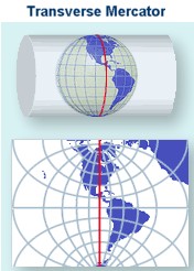
2.   Projection (PROJECTION), which is the projection from geographic coordinates (lat/long) to projected coordinates.  This is essentially how the three-dimensional spheroid (Earth) is projected to a two-dimensional viewing medium.  In the example above, Transverse Mercator is selected, which uses the Universal Transverse Mercator (UTM) coordinate system.


Cylindrical projection - transverse aspect © USGS

3.  Various projection parameter values (PARAMETER).  The parameter is labeled in quotations, followed by its value. 
4.  Units for the projected coordinate system (UNIT).  Here meters are used as the linear unit with a conversion factor of “1”.  The conversion factor converts the described units into meters.  If “FOOT_US” is used, then the conversion factor would be 0.30480060960121924.

There may be some additional clauses in your projection file, but the ones listed above seem to be typical.  All of the keywords used in WKT format with descriptions can be found at GeoAPI here.
You can write your own projection files and GeospatialPython.com presents a method (there are other examples out there, just Google it).  However, it is much easier and much more practical to find an already-compiled projection file and use that.  If you have a georeferenced HEC-RAS project already, every shapefile used to create your geometry components (stream centerline, xscutlines, flowlines, etc.) comes with a projection file.  Just find where it is stored on your computer and use that. 

If you don’t have the GIS files that were used to create your georeferenced HEC-RAS project, you can find projection files in at least three different places:  ArcGIS 10.0 or earlier, spatialreference.org, and the EPSG Projection Database.  If you know of others, please comment below!

When using any of these sources, make sure you pick the correct projection file.  You’ll know if it is the right one by bringing in web imagery to RAS Mapper and checking to make sure that everything lines up spatially correct.  ArcGIS (Versions prior to 10.1) includes a Coordinate Systems folder that contains more than 5,000 geographic, projected, and vertical coordinate systems.  Unfortunately, newer versions of ArcGIS do not come with that folder.  If you have ArcGIS 10.1 or newer or don’t have ArcGIS at all, you can access a large database of spatial reference systems at http://spatialreference.org/

image


If you go to spatialreference.org, make sure you only select from the EPSG, IAU2000, or spatialreference.org references.  The ESRI references only contain the GEOGCS clause in the projection file and not the complete PROJCS clause.  They will not work in RAS Mapper.   Once you’ve found the reference you want, click on it, then select “.PRJ File” from the list of available formats.  A projection file will then be downloaded to your computer and you are ready to use it in RAS Mapper.  There is a convenient Search box that allows you to search on key words for your reference.  For example, if your project is in Hawaii and you know your horizontal datum is NAD83, you can enter the keywords:  Hawaii NAD83, click the Search button and you’ll see the following list of spatial references:

image

Also available on line is the EPSG Projection Database, hosted on GoogleCode by geospatialpython.org.  Here you'll find a text file of a multitude of projection files in the correct WKT format that can easily be copied and pasted into your own projection file.

Once you’ve selected a projection file and assigned it to RAS Mapper, double-check that it is correct by adding web imagery.  If everything lines up, you are good to go.  The figure below shows the Muncie dataset in RAS Mapper, with an incorrect projection file assigned.

image

Obviously our streamlines and cross sections in this example are not correctly aligned in Muncie Indiana where they belong.  The incorrect projection file has landed us in the middle of Alberta, Canada!

image


Reassigning the correct projection file gets the model back to its correct spatial reference.

image

image

Does anyone know of any other sources of projection files that we can use in HEC-RAS?  If so, please comment below.

My Unsteady HEC-RAS Model is Unstable…Why?

$
0
0
Written by Christopher Goodell, P.E., D.WRE  |  WEST Consultants
Copyright © The RAS Solution 2015.  All rights reserved.

This question (or some variation of it) comes up quite a bit on The RAS Solution:  “I have an unsteady flow model.  When I run it, it goes completely unstable.  What is causing this?”  Many times a screen shot of the computation window with the dreaded “red bar” is attached.  

image

While the person asking the question genuinely needs help, what he/she doesn't understand is that it is impossible for anyone to troubleshoot his/her model with this limited amount of information or without the model data files.  There are an almost infinite number of possible reasons the model crashed.  

If I could sum up my approach to troubleshooting unsteady HEC-RAS models in one sentence, it would be
“HEC-RAS likes things to change gradually”

If your model is crashing, look for places or times where something is changing drastically.  It could be a sudden and significant change in the size and shape of the main channel from one cross section to the next.  It could be a sudden increase/decrease in flow.  It could be a sudden increase/decrease in stage.  Whatever steps you take to try to stabilize your model, make sure you are confident that the steps you are taking will improve stability without giving up more accuracy then you’re willing to sacrifice.  Haphazardly making changes and adjustments to your model without any forethought or strategy, in an attempt to make it stable could very well make it worse and get you nowhere-and waste a lot of time.  Making methodical, logical, and beneficial changes to your model is a much better approach.  By methodical, I mean understand what you are doing, and why it can improve numerical stability.  Also understand what accuracy (if any) you are sacrificing to achieve the increased stability.  Keep in mind, stabilizing your model may require more than one “change”.  This is why it is important to understand the theory behind the computations in HEC-RAS.  That understanding will allow you to make informed and intelligent decisions on what techniques to use to stabilize your model. 

Here are some very helpful references that deal directly with how to troubleshoot HEC-RAS unsteady flow models that are unstable and/or crashing.  If you’re having trouble with your unsteady flow model, please carefully read through these references.  And consider taking an HEC-RAS training course if you can.  The “Unsteady Flow” and “Dam Breach” classes both cover techniques for troubleshooting an unsteady flow HEC-RAS model. 
  • HEC-RAS User’s Manual Chapter 8, Performing an Unsteady Flow Analysis.  Particularly the section on Model Accuracy, Stability, and Sensitivity.  This manual (along with the Hydraulic Reference Manual) comes with the installation of the HEC-RAS software.  You can access it from the main HEC-RAS window under Help…User’s Manual.
image


image


[clip_image002%255B5%255D.jpg]

 Stabilizing a Dynamic Unsteady HEC-RAS Model.  Post on The RAS Solution.  Steps taken to stabilize a HEC-RAS model, along with the dataset used.  http://hecrasmodel.blogspot.com/2013/10/stabilizing-dynamic-unsteady-hec-ras.html


image


image

Viewing all 200 articles
Browse latest View live